Northern Alabama - Decatur - Priceville
Today is
This free script provided by
JavaScript
Kit
Severe/Hazardous Weather,
Huntsville
Office, National Weather
Service
Storm Prediction Center, NCEP,
NWS
Weather Station at Pryor Field, Decatur, AL - Conditions - Last Three Days | Meteogram
|
|
|
|
|
|
|
|
|
|
|
Station KEET in Birmingham, AL
|
Sounding for Decatur, AL
|
|
Skew-T Questions
Questions concerning values displayed on the SKEW-T graphic that expand understanding of the stability of the air mass over this area, together with its potential for severe weather:
Sounding variables and indices
Y
/ N -
L57 Lapse Rate: Greater than 5.5°
C/km?
greater than 6.7°
C/km?
Y
/ N - Is the Theta-E
Index greater than 5? Greater than 8?
Y
/ N - Lifted Index (LI):
Less than -4? Less than -8?
Y
/ N - Showalter Index
(SI): Less than -4? Less than -8?
Y
/ N - Total Totals Index
(TT): Greater than 53? Greater than 56?
Y
/ N - K Index (KI):
Greater than 26? Greater than 40?
Y
/ N - SWEAT Index
(Severe Weather Threat Index): Greater than 300? Greater than 400?
Y
/ N - Energy Index (EI):
Less than 0? Less than -2?
Parcel Indices
Y
/ N -
CAPE ( Convective available potential energy): Greater than 1,500?
Greater than 2,500?
Y
/ N -
CINH (Convective inhibition): Greater than 51? Greater than 200?
Y
/ N -
CAP: (Cap strength): Greater than 2.0? Greater than 4.1?
Y
/ N -
Super-adiabatic lapse rate – where the temperature decreases
with height – at a rate of greater than 10 degrees Celsius per
kilometer? (data is displayed on the NWS
Skew-T
Sounding Charts
in
the lower left corner)
Wind Parameters
Y
/ N - HEL (Storm
relative helicity): Greater than 300? Greater than 400?
Y
/ N - EHI
(Energy-Helicity Index): Greater than 1? Greater than 5?
Y
/ N - BRN (Bulk
Richardson Number): Less than 45? In the teens?
Y
/ N - Upper level winds
(between 500 and 300 mb level) of greater than 100 knots?
Y
/ N - Low level winds
(850 to 700 mb) at 25 knots or greater?
Y
/ N - Atmospheric winds
increasing at higher
levels (upper level
speed shear greater than 70 knots)?
Y
/ N - Atmospheric winds
from different directions
(directional shear of 60 degrees or
more from the surface to 700 mb)?
Current Surface Conditions
Y
/ N - Dew Point greater
than 55 degrees?
Y
/ N - Temperature
greater than 80 degrees? In the forecast? - Y
/ N (High temperature
and high dew point indicates high instability, increasing the threat
of severe weather.)
Y
/ N - Relative Humidity
(RH): Greater than 50%? Greater than 80%?
Y
/ N -
Is there a 30 to 50 degree surface temperature/dew point spreads?
(High microburst potential.)
When these values indicate the potential for severe weather, or where there is some questions about the values displayed on the graphic, I bring up the Text version of the SKEW-T and check the appropriate values.
|
PW - Moisture Content:
0.50 inches or less = Very low |
Dew Point Greater than 75° = Very high 65-74° = High 55-64° = Moderate Less than 55° = Low |
Low Level Jet Greater than 70 knots = Extremely high 50-69 = Very high 30-49 = High 20-29 = Moderate Less than 20 = Low |
Additional Variables to Watch: Vertical Wind Shear, Veering, Mid-level Cap, Helicity.
See also SKEW-T for Birmingham, AL.
See generally "Getting to Know the SKEW-T Parameters" by meteorologist Jeff Haby.
|
|
Current
Conditions-Willow Place
Current Weather in Priceville, AL (Cumulus)
KALDECAT4
| CW7715
| PWS Weather
Pryor
Field, Decatur, AL - Current
Conditions |
Meteogram
|
Text
Archive
|
|
|
Southeast Sector - Storm Prediction Center Mesoanalysis Sectors
|
|

|
|
|
|
|
|
|
24 Hour Forecast | 48 Hour Forecast | 3 Day | 4 Day | 5 Day | 6 Day |
Huntsville Weather Forecast Office
|
|
|
|
|
|
National Forecast
Model Maps
National Weather Service
Short Range
24
hour
48 hour
Medium Range
Day 3
Day 4
Day 5
Day 6
A few of the additional weather pages on this web site:
Daily Weather Charts - Complete
Huntsville Weather Forecast Office, National Weather Service
Short Term Forecast
(The 6-Hour NOWCAST).
Not issued during fair weather. Access only during inclement weather;
carefully check the date and time.
Special Weather Statements
Issued infrequently; carefully check the date and time.
Storm Reports
Storm specific; carefully check the date and time.
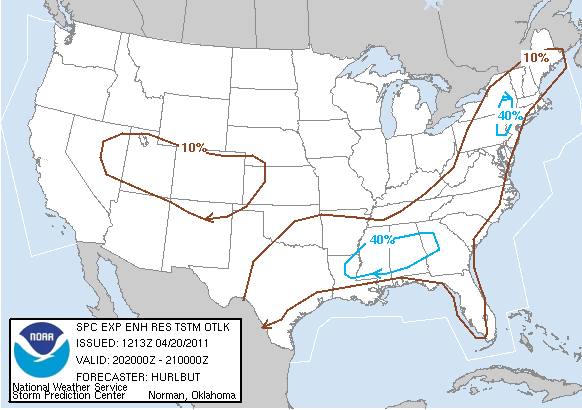
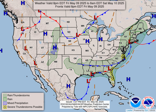
Storm Prediction Center: Watches, Mesoscale Discussions, Outlooks
|
|
|
|
||
|
|
AF4AX
|
|
||