Hazardous Weather Outlook
|
|

Today is
This free script provided by
JavaScript
Kit
As a National Weather Service SKYWARN storm spotter, I like to keep a close eye on the weather, especially when severe weather is in the forecast. Each morning, this page is my first look at the weather. The purpose of this page is to answer these questions:
Is today a severe weather day?
If so, what, where and when?
Is severe weather within the three to five day forecast?
Does the National Weather Service anticipate that storm spotters and emergency management personnel may or will be activated? Note: The "Spotter Call to Action Statement" in the Hazardous Weather Outlook is of particular importance.
If the answer to any of these questions is "yes," I then turn to the Graphical Weather Forecast web page and the Daily Weather Charts web page. These pages allow me to become aware of potentially strong or severe storms that will be moving into this area in the next few days, and to immediately begin preparing for the effects of these storms, so that on the day of the storm I can devote primary attention to the job of providing "ground truth" to the NWS.
Huntsville Weather Forecast Office
|
|
Weather
at
Pryor
Field, Decatur, AL -
Conditions
- Last Three Days |
Meteogram
Radar for Huntsville
All links open in a new window at an external
site.
Weather data from my personal weather station is
not posted due to failure of the rain gauge.
Hazardous Weather Outlook
|
|
Area Forecast Discussion
|
|
Day 1 Convective Outlook |
|
Day 2 Convective Outlook
|
Day 3 Convective / Severe Thunderstorm Outlook
|
Day 4-8 Convective / Severe Weather Outlook
|
North America Water Vapor Image

 |
 |
 |
| 250 mb Upper Air Map | 500 mb Upper Air Map | 850 mb Upper Air Map |
 |
 |
 |
| SPC Activity Chart | Categtorical Outlook | Tornado Outlook |
 |
 |
 |
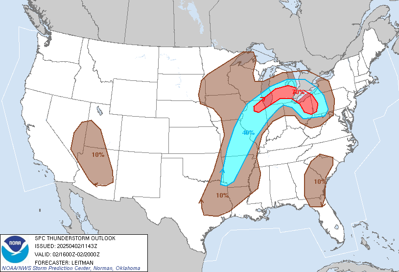
| Thunderstorm Outlook 16Z-20Z [1100-1500 CST] |
Thunderstorm Outlook 20Z-00Z [1500-1900 CST] |
Thunderstorm Outlook 00Z-04Z [1900-2300 CST] |
National Hurricane Center Two-Day Tropical Outlook
Pacific & Atlantic
National Forecast
Model Maps
National Weather Service
Short Range
24
hour -
48 hour
Medium Range
Day 3 -
Day 4 -
Day 5 -
Day 6
Weather Prediction Center, National Weather Service
A few weather pages on this web site:
Daily Weather Charts - Complete
National and Local Radar (especially helpful in tracking storms moving into the state and this county)
Hazardous Weather Quick Look (the several NWS web pages used during strong or severe storms; carefully check the date and time of the statement, report or alert)
West Atlantic Satellite Images (during hurricane season)
Huntsville Weather Forecast Office
|
Storm Prediction Center, National Weather Service
Daily Briefing, NWS
Links to College of DuPage Next Generation Weather Lab:
Local WX
|
Alabama WX Blog (Spann)
|
|
Return home
to:
A Treasury of
Christmas Carols
![]()
|
Please help spread the good news at Facebook about the over
4,300 Christmas hymns and carols at this web site:
Thanks! |
|
|
|
|
||
 |
 AF4AX
|
 |
||


